The Sundarbans in Bangladesh. Image used for representative purposes only. Photo: Wikimedia Commons
For 16 years, a modest floating laboratory in the Indian Sundarbans, comprising the world’s largest mangrove forest ecosystem and also one of the most endangered, has been quietly tracking this marine realm’s intricate biological and chemical rhythms.
Once plagued by rampant mangrove clearing, the Sundarbans, a UNESCO World Heritage Site and home to the iconic royal Bengal tiger, has seen historical deforestation slow and the big cat population stabilise.
But the mangrove ecosystem, rooted in a region constantly sculpted by tectonic activity, tidal action, and river erosion, still faces multiple risks due to its historical habitat loss. Despite recent stabilisation, the IUCN (International Union for Conservation of Nature) Red List of Ecosystems has classified the Sundarbans as endangered
The spectrum of risk includes agricultural expansion, aquaculture, overharvesting of natural resources, poaching, rising salinity from sea-level rise, more intense cyclones and droughts, river engineering projects, pollution, and ongoing mangrove loss from development.
These shifts threaten to upend the delicate balance of temperature, salinity, nutrients, and tidal rhythms that sustain mangroves. The stakes are high: the Indian Sundarbans supports four million people, with wild fisheries providing the region’s second-largest source of jobs.
The Indian Sundarbans supports four million people, with wild fisheries providing the region’s second-largest source of jobs. Photo: Sahana Ghosh
Against this backdrop, the floating lab has kept up a steady rhythm — trip after trip, collecting samples and measurements that feed into the Sundarbans Biological Observatory Time Series, or SBOTS.
Run by researchers at the Indian Institute of Science Education and Research, Kolkata (IISER Kolkata) since 2010, the time series is like a diary of the delta, filled in week after week, year after year, with data points on water quality, the ebb and flow of microbial life, and the seasonal rhythms that pulse through the mangroves.
“Each entry is a measurement taken at regular intervals over time,” Punyasloke Bhadury, a scientist and professor at IISER Kolkata, who helms the time series tells us.
It’s one of the few long-term recording systems in the delta, keeping a close watch on how the system changes over time. Then, using those patterns, crunched through statistical models, one can gain insights into what the future might hold.
You can’t properly protect something you don’t understand, and you can’t understand something without observing and monitoring it. When a patient is in a hospital, they are constantly monitored to guide their treatment. This is needed to track the illness, but also to look for signs of recovery. The same is true for the ocean. Long-term monitoring, such as the ones in Bermuda and Hawaii for ocean acidification, allows us to identify problems but also to check if solutions or conservation efforts are working. – Steve Widdicombe, Director, Sharjah Marine Science Research Centre, UAE.
To ensure the Sundarbans time series stays consistent, the team, like clockwork, sails into the delta on a weather-beaten boat armed with GPS monitors and sensors, week after week. Amid the steady thrum of the anchored vessel, they lower pails into the water, fetching samples to test more than 30 vital parameters. Some measurements are logged immediately, while others await stringent laboratory analysis once the water samples are returned to the institute’s laboratory.
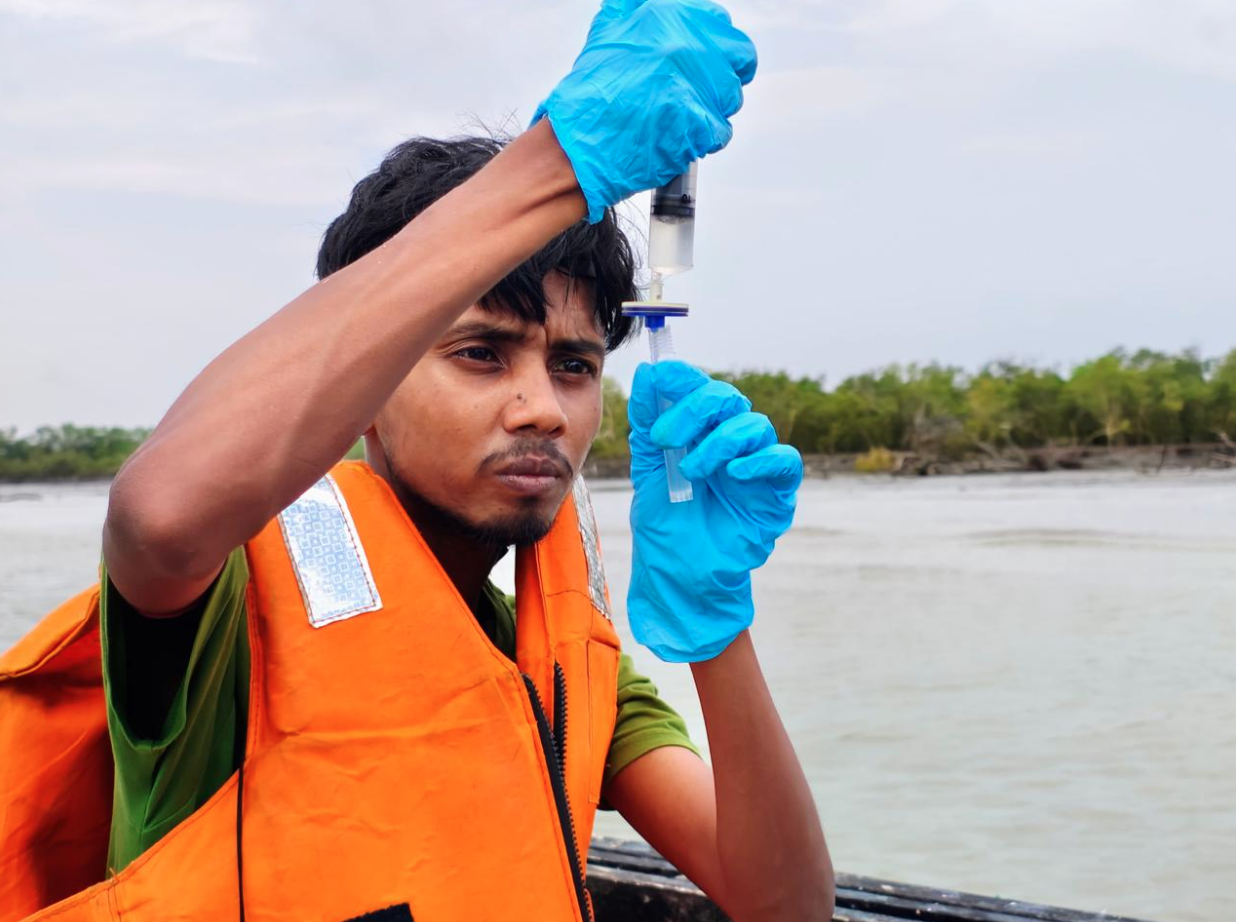
The team from IISER sails into the delta to fetch samples and test vital parameters such as the water quality, the ebb and flow of microbial life, and the seasonal rhythms that pulse through the mangroves. Photo: IISER Kolkata.
One key monitoring site lies in the mangrove-hemmed creeks of the Mooriganga estuary.
The Muriganga river, a tidal alluvial channel of the Hooghly, feeds the Sagar Island, the largest of the Indian Sundarbans’ 102 islands. It plays a central role in shaping the island’s coastline. Remote sensing analyses have shown that Muriganga’s area expanded by 16.82 percent between 1972 and 2021, while shoreline erosion along its banks progressed at a rate of 2.06 to 5.73 meters per year.
These rapid geomorphological shifts make the estuary a vantage site for monitoring how physical changes in the delta influence mangrove stability and resilience, notes doctoral scholar Nirupama Saini at IISER Kolkata.
A recent study that taps into the data assembled by the floating lab — in tandem with carbon dioxide measurements from 2013–2015 — shows that mangroves are standing strong, bouncing back from storms and against growing pollution, at least for now.
Stressed mangroves can recover within one to two weeks. Additionally, satellite records that mapped photosynthetic activity showed a peak in mangrove growth during the monsoon. This means that even as essential nutrients like nitrogen and phosphorus declined, largely due to upstream agricultural and urban pollution,the mangroves continued to grow, photosynthesise, and remained productive.
“But their survival in the future depends on pinpointing thresholds beyond which they may not recover — and only sustained monitoring can reveal those,” Bhadury says.
Warning against complacency, Widdicombe says that ecosystems don’t always show a linear decline with increased pressure. He adds that many examples of biological systems and processes show some adaptation or resistance up until a critical point, but when the stress gets too much to cope with, the consequences are catastrophic.
Biological resilience is good news, but it should not be seen as an excuse to do nothing, and “we must continue with our efforts to protect the ocean and the incredible species and habitats it contains,”he adds.
Continuous and repeated monitoring allows researchers to move beyond snapshots of stress response and instead explore the complete resilience cycle – disturbance, adaptation, and recovery – under both natural and human-induced pressures. A recent research led by scientists from the University of Arizona and Rutgers University underscores the fragility of this resilience.
They examined 22,000-year-old sediments dug out from the Mahanadi Basin in the Bay of Bengal delta. These contained fossilised shells of tiny single-celled marine organisms, called planktons, which form the base of the food chain.
Because these organisms record environmental data in their calcium carbonate shells as they grow in the water, scientists were able to reconstruct the delta’s dramatic past by studying them. It turns out that 22,000 years ago, long before industrialisation, monsoon fluctuations reduced plankton levels in the Bay of Bengal, halving the surface ocean’s food supply. And it can happen again if the ecosystem risks crossing ecological tipping points, especially now under human-induced warming.
To capture these shifts and critical thresholds in real time, SBOTS is expanding into citizen science, drawing on the fisher community’s deep familiarity with the delta. Under ‘Sagar Prahari’ (or ocean guardians in Bangla) initiative, as many as 15 local maritime data collectors – the fisher community members — will be trained to log observations, operate monitoring sensors, and feed measurements of temperature, pH, salinity, and other parameters into scientific databases.
“Their lived realities will contribute to documenting changes that might otherwise go unnoticed by us. Our lab-on-the-boat will be the hub; the citizen scientists will be the spokes,” Bhadury explains.
Ocean science is increasingly seen as a collaborative effort, with the International Science Council’s Ocean Expert Group urging partnerships that guided the 2025 UN Ocean Conference and Ocean Declaration.
Without long-term time-series monitoring programs, the impacts of climate change and human activities on crucial biogeochemical cycles, such as carbon storage in the Sundarbans, will remain unresolved. – Nirupama Saini, IISER Kolkata.
A true picture of the delta will only come into focus when data from India and Bangladesh are woven together. In Bangladesh’s Sundarbans, however, such data is scarce. “Research and monitoring are mostly project-based and sporadic,” says Mohammed Mofizur Rahman, formerly with the Potsdam Institute for Climate Impact Research in Germany. “Many studies rely on perceptions or expert judgment. We haven’t reached the stage of data-to-decision making.”
Fragmented datasets, the rush to publish using secondary sources, and difficulties unifying information across agencies hamper such informed decision-making.“Long-term ecological monitoring is crucial for restoring transboundary ecosystems,” Rahman adds.
“We are not there yet, but it could be an avenue for soft diplomacy.”